RCARP receives THC Historic Preservation Grant

Every year the Tennessee Historical Commission (THC) awards grants to organizations for projects that promote the understanding and preservation of historic and archaeological resources. This year the THC awarded funding to 36 such projects, and the MTSU Rutherford County Archaeology Research Program was one of those recipients.

So, what is RCARP going to do with the grant funds? Well, we will return to the Magnolia Valley site in summer 2016 to investigate additional anomalies detected during the 2014 geophysical survey and survey areas suspected to have evidence of ancient human occupation. Some of these anomalies are associated with the Archaic period occupations of the site (ca. 5,000 years before present), others we suspect may be associated with the late prehistoric Mississippian period. The Mississippian period occupations of what is now Rutherford County are not well researched nor understood. This THC grant-funded work will allow us to learn how and why people settled in this particular part of the county and add to our knowledge of Native Americans’ relationship with the landscape.

For updates on our progress, subscribe to this website. You’ll receive an email when we update our blog (and that is the only time we will email you, promise!). Just click on the “FOLLOW” button on the lower left side of the homepage.

Click on the "FOLLOW" button to be notified when we update our blog!

Click on the “FOLLOW” button to be notified when we update our blog!

You can read more about the program and the grants awarded to MTSU here.

Click here or a list of all grants awarded this cycle.

30 Days of Tennessee Archaeology, Day 22

RCARP’s Public Outreach and Education Coordinator, Laura Bartel, focused on the public outreach mission of RCARP in today’s edition of the “30 Days of Tennessee Archaeology” blogfest. A great rendition of what we did this summer and our plans for the future. Be sure to see the information on our Open House this weekend at the end of the blog.

Tennessee Council for Professional Archaeology

Dig and Dine: Introducing the Rutherford County Archaeological Research Program to the community

Laura Fyock Bartel, M.A.
Independent Archaeologist
Public Outreach and Education Coordinator, RCARP

Most professional archaeologists recognize the importance of public archaeology programs, and where feasible, try to incorporate some sort of public outreach and activity along with their projects. The Rutherford County Archaeological Research Program (RCARP), a new program based at Middle Tennessee State University (MTSU) and directed by Dr. Tanya M. Peres, Associate Professor of Anthropology, focuses on prehistoric archaeology in Rutherford County, Tennessee. Previous posts for the “30 Days of Archaeology” have discussed RCARP and its Magnolia Valley project.

As Public Outreach and Education Coordinator for RCARP and an archaeologist myself, I have the exciting opportunity to assist Dr. Peres in engaging the public with the prehistory of Rutherford County. I would like to share how we have begun our public outreach program.

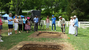
Tanya Peres and Jesse Tune describe the excavation process for visitors Tanya Peres…

View original post 905 more words

Life in the (outside) Archaeology Lab, Part II

As was mentioned in the previous post, we have many samples that are undergoing a process called “flotation.” We have well over 400 bags that range from 20-100+ lbs of feature samples to process this way. The students are working in 4-5 hour shifts five days a week to complete all of these by Friday, August 8th (and will be rewarded with a BBQ picnic lunch prepared by me, Dr. Peres! [and a good grade, too]). We have been fortunate to have an awesome faculty and staff at the MTSU Greenhouses that have given us lots of space, logistical support, and interest to get this job done. It is helpful for them, too — they get all of the organic residual sediments for composting. So thanks to Dr. Nate Phillips, Larry Sizemore, the Greenhouse staff, and of course the graduate students, who have taken an interest and given us a flotation home!

The rest of the blog post is by Clacey Farley and Lee Van Sickle. I challenged them to not only write a post about flotation, but to be creative and “make a video or something.” They did a great job on their first video to show you, our blog readers, what they do every day.


***************************************************

by Clacey Farley and Lee Van Sickle

What is flotation?

Flotation = Reduction, very systematically.
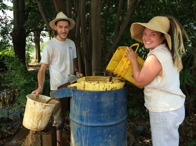
We take large bags of sediment rocks and other items, wash, and reduce them to smaller bags for further analysis. We pre-soak the large bags in water-filled buckets before transferring them onto a large set of screens inside of a 50 gallon flotation tank that resembles a giant pitcher.
Lee and Clacey working at the flotation tank.

Lee and Clacey working at the flotation tank.

Inside the tank is a small sprinkler to generate water for washing off the dirt. The heavy items (fire cracked rocks, flint, etc.) or heavy fraction sink to the bottom of the screens and are removed and placed on trays to dry. What happens to the stuff that floats to the top? Well, the lighter items (plant remains, carbonized pieces, etc.) or light fraction cascades out of the top of the tank and into a bucket with another sieve to catch it. It is then placed on a separate tray for drying, just like the heavy fraction and then they are both dried and bagged again alongside tags indicating which feature the material is from. Then they are taken to the lab where another team processes them further.
As of Thursday, July 31, over 336 bags had been floated. This includes down-time for patching and repairing torn screens, building mud walls to divert the runoff to a specific location, lectures in the archaeology lab, and the unloading of more bags as they are brought in from field storage. We’ve learned the value of multitasking and the importance of double- (and triple-) checking! It is also nice to know that we can trust our teammates to do the same. When we have to look away, we have the security of knowing the project is still in safe hands!​

Life in the Archaeology Lab, Part I

RCARP operations moved to the lab in July after a much-needed week off following the end of fieldwork.

Did you know that fieldwork is just a small fraction of how an archaeologist spends her/his time? A general rule of thumb for how an archaeologist spends their time is:  one 40 hour week in the field (per person) = three 40 hour weeks in the lab (per person). We spent SEVEN 40 hour weeks in the field at Magnolia Valley. This equals twenty-one 40 hour weeks in the lab. But wait, that is per person. Our crew consisted of 17 people on site each day. That means we can look forward to 357 40-hour weeks in the lab (not including the Geophysical survey and data analysis). This time will be spent washing and sorting artifacts, processing 100% samples through a process called flotation, checking all field notes and forms, digitizing field maps, analyzing and cataloguing artifacts, entering data, and eventually writing reports, articles, lectures, posters, blog posts, and public talks.

Today we will get a glimpse on how we start to tackle that long to-do list.

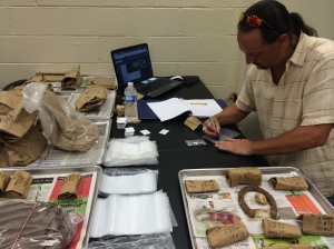
Two weeks ago we began the long process of organizing the hundreds of bags of artifacts and double-checking that all information on the bags and in the FS log are the same. FS stands for Field Specimen number (abbreviated on all paperwork and bags as FS#). This is a unique number given to each different provenience during excavation. For example, a shovel test will get its own FS number so that no two shovel tests have the same FS#. Each 10-cm level of an excavation unit is assigned its own FS#. The artifact bags are arranged in boxes FS# order, from 1 to 345. This corresponds with the FS Log and allows us to quickly locate any given bag of artifacts we are interested in.

The early stages of artifact processing.

The early stages of artifact processing.


As the bags are being checked for accurate information, all artifacts within them are also being washed, dried, sorted by artifact category, and re-bagged. This is the initial step in analysis, which will commence once all of the artifact bags have undergone this process. You can read more about how we go about washing artifacts and also the flotation process in the coming days.

Guess what day it is?

— post by Dr. Peres

We have yet to recap Week 7 – between the rain, threats of rain, visits by VIPs, and all-out-feature excavation, well, we (that would really just be me, Dr. Peres) have slacked off on blog posting. But today is the day we backfill, and we still have a lot of prep work to finish before we move the ridges of backfill dirt into our excavated units.  I will offer up a recap of our whirlwind last week of excavations and our biggest public outreach event to date over the next few days. As always, you can catch glimpses of our work during the day on Facebook, Instagram, and Twitter.  #rcarp

What day is it?

Every backfill day needs a meme.


GOOOOOAAAAAALLLLLLLL!

— post by Dr. Peres

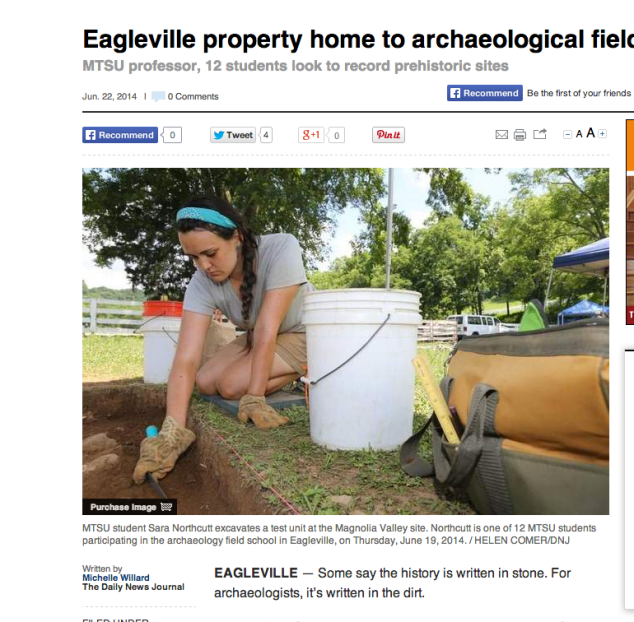
We are in the thick of trying to finish up our excavations for the field season and continue to fulfill our goal of community outreach and public education. The first two days of this week have been filled with all of the above! The Daily News Journal ran a feature story (on the FRONT PAGE) of our work this summer. Michelle Willard (@MichWillard), the DNJ reporter that visited us on-site, is to be commended for writing up an accurate and exciting account of what RCARP and our field school are all about. We currently have a laminated copy of the article hanging in the lab!


Cover story (in print and on-line) of the DNJ on 6.23.14

Cover story (in print and on-line) of the DNJ on 6.23.14

On Tuesday we hosted about 30 MTSU VIPs for the inaugural “Dig & Dine” to showcase the great work of the archaeology faculty, staff, and students at MTSU. I want to write a longer post on this as it was a great event that created a lot of enthusiasm for archaeology in Rutherford County. We were honored to have MTSU President Dr. Sidney McPhee and First Lady Liz McPhee, as well as University Provost Dr. Brad Bartel, on hand for the event. Here is a picture from the event with a longer post and more pictures to come!

 Dr. Tanya M. Peres and Jesse Tune, Co-Directors of the Magnolia Valley Project, show MTSU President Dr. Sidney McPhee the earth oven feature.


Magnolia Valley Field School: Week 6 Recap and Looking Ahead to the End

— post by Dr. Peres

I know the blog has been quiet the past few days and for that I apologize. We have finished Week 6 and are now into the home stretch! Our days on site are less about the physical nature of our work (though it is still not for the out-of-shape) and more about the intellectual side of archaeology. One of the aims of archaeological excavations is to uncover physical evidence of humans whereabouts and activities in a given area. Of course artifacts (any object made, modified, or used by humans) can tell us some of this, but what really interests archaeologists are the features (evidence of human activity that cannot be removed, such as a post hole or hearth). The remote sensing work that was completed at the site is the basis for our excavation strategy. We are targeting several areas of intense anomalies.

Week 6 was about identifying features in the floors of our excavation units as soon as possible (which is one of the reasons archaeologists dig in small controlled increments), then open up more units as necessary to expose the entire surface of any given feature. This has resulted in a total of 19 excavation units open: 16 of these are 2 meter x 2 meter squares and the remaining 3 are 1 meter x 2 meter rectangles. We have exposed a total of 8 features, most of which are large and occupy more than one excavation unit. Here is a quick summary of what we know about Features 1-5 this far.

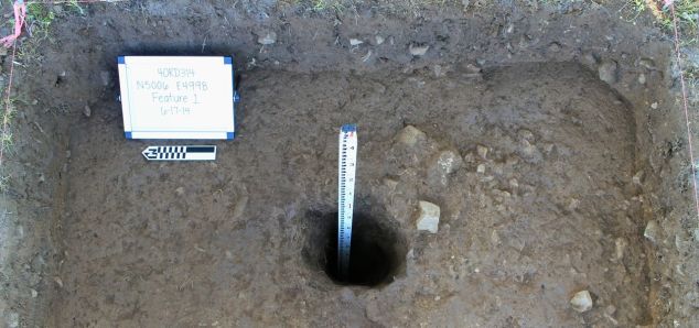
Feature 1: a posthole — not modern, maybe historic, likely older than that. This feature was first thought to be a natural tree feature, as the top outline was circular, but without distinct edges. In actuality it was the very top of the post hole, something we rarely, if ever, see in Southeastern Archaeology as most features have had the top 20-30 centimeters plowed off. Lucky for us, our site has never seen a mechanical plow. In fact, according to Susan’s research, Magnolia Valley has almost exclusively been in horse pasture. I know I have never worked on a site in the Southeastern US that did not have a deep and oftentimes destructive-to-the-site plowzone.

This feature was excavated to a depth of over 1 meter.

Feature 1, excavated.

Feature 1, excavated.


Feature 2: the historic two-track horse and wagon/buggy/carriage road. (Pictures to follow another day.)


Feature 3: a possible earth oven.


Feature 4: very large feature located to the north of Feature 3. We have opened seven 2 m x 2m and one 1 m x 2 m units to expose this feature in its entirety. We will work on documenting and excavating this during our final week on-site. We anticipate their being additional features within this one large one.


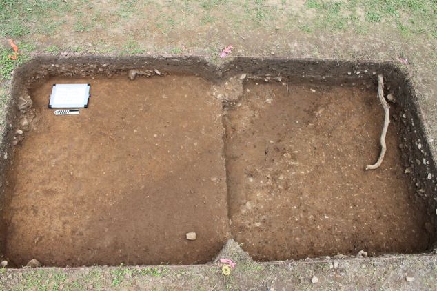
Feature 5: a long, mostly linear, slightly curving trench-like feature. We have it exposed in three 2 m x 2 m units. What is exposed is being excavated.

Plan view of Feature 5 in two consecutive units (not yet excavated).

Plan view of Feature 5 in two consecutive units (not yet excavated).


Features 6-8 are still in need of further defining before we can discuss them in any depth.


Also this week we saw a number of visitors to the site. We had a local school group of students, parents, and several teachers come and learn about archaeology with some hands-on activities. A number of MTSU faculty and alumni stopped in (and brought popsicles!) to check out our work. We love sharing what we are learning with our friends, colleagues, and anyone that is interested.

Stay tuned as we work to finish up an exciting field season at Magnolia Valley!

On the road in Allisona

— post by Susan London-Sherer, Historical Archaeology/Historic Preservation Graduate Intern

Although the timeline related to the road that we exposed in our excavation unit remains uncertain, the research that I have been doing related to it has been fascinating.  We now know that a road from James Allison’s property was ordered by the court, and that local men were appointed to build this road from 1807 to 1809.  We cannot be certain yet that the road in our unit is indeed part of this particular court-ordered road.  So, it is necessary to investigate further, to consider other avenues…take a detour, so to speak, into alternate possibilities.

If you will remember back to my last blog post, I wrote about the uniform-sized rock that my colleagues diligently shoveled and screened for days.  In researching early road construction, and in discussion with Co-Director Jesse Tune, we came up with an interesting concept that just might apply to the road in our excavation unit, and place a slightly later date on our road.

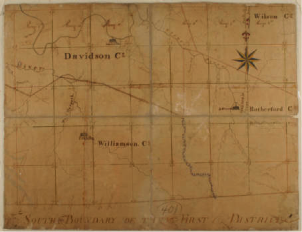
Map of the First Surveyor's District of Tennessee, circa 1807-1808 Digital Image © 2008, Tennessee State Library & Archives.

Map of the First Surveyor’s District of Tennessee, circa 1807-1808
Digital Image © 2008, Tennessee State Library & Archives.


We came across the name John Loudon McAdam, a Scottish engineer, who developed a new system for road construction in 1820.  The size and weight of each stone was the most important element of McAdam’s technique.  Men sat with small hammers and carefully broke up rocks into different sizes, which were then laid in layers with the largest on the bottom and the smallest on the top.  The largest stones, which comprised the bottom 7.9 inches of road surface, were to be no bigger than three inches in diameter.  The top two inches of the road consisted of stones no larger than .79 inches in diameter.  The road building crew was under strict supervision and the size and weight of their rocks could be checked in a variety of ways.

Sometimes road crew supervisors carried scales with them and made sure the rocks did not exceed a maximum weight of six ounces.  If no scale was available, sometimes supervisors carried metal rings that each rock had to pass through to certify its size.  The road crew also had a third option of guaranteeing the size of their rocks.  If they were able to fit the rock inside their mouths, then it was approved to go on the roadway.  McAdam’s technique also required that the men lay the road one careful shovelful at a time.

Workers break up rocks for a McAdam’s road.   This is where the term “macadam” road surface comes from. Photo courtesy of wikipidia.com

Workers break up rocks for a McAdam’s road.
This is where the term “macadam” road surface comes from.
Photo courtesy of wikipidia.com


If indeed, our road dates to a later time period, specifically after the first macadam roads were constructed in the United States in 1823, a whole new set of questions begs to be answered.  Where exactly were the early residents of Allisona going?  What kinds of places did they want, or need to visit when they traveled along this road?  What kinds of businesses developed in the region due to the construction of the road and the access it provided to the settlers?

As you can see, with each day that passes at the Magnolia Valley site, and with each new discovery that we unearth, our research questions take on new shapes and dimensions.  The more ways that we can confirm human activity on the landscape, the more significant our research becomes.  This journey began when a revealing snapshot of something that “looks like a road” was discovered in the data from our initial geophysical survey.  The road was later confirmed through the controlled excavation of a two-meter by two-meter excavation unit laid out on a grid with the same coordinates as the geophysical survey.  The historical document research revealed a contemporary road-building technique that appears to back up the description of the uniform-sized rocks that covered the road in our unit.  In this case, the detour that I took on the road to discovery led me on a quest to a precious hidden gem of knowledge.


Magnolia Valley Field School: Week 5 Recap

— post by Dr. Peres

We have just finished Week 5 of the MTSU Field School at Magnolia Valley. This means only TWO WEEKS left before we close the site.

Monday was a complete wash and we spent the day in the lab washing, sorting, and bagging artifacts for analysis later this summer.

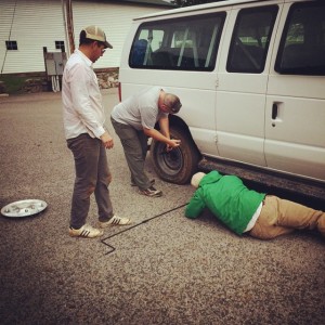
We were able to start our Tuesday at the field site and get in a few hours of work before the rain rolled in and we had to close up the site for the day. Just as we finished closing up the site and were preparing to head back to campus, we noticed the field school van had a punctured tire and was quickly going flat. Luckily, Field Assistant Joey K., was able to change the tire so we could get it back to motor pool and get a “fresh” van.  The rest of the day was spent in the MTSU Archaeology Teaching Lab. Jesse gave a mini-lecture on lithic analysis and I gave a talk on how to prepare a Curriculum Vitae (CV) — basically a long resume that details one’s education, work experience, research, publications, etc.

Field Assistant Joey Keasler changes the flat tire on the field school van (with help from the students). Thanks guys!

Field Assistant Joey Keasler changes the flat tire on the field school van (with help from the students). Thanks guys!

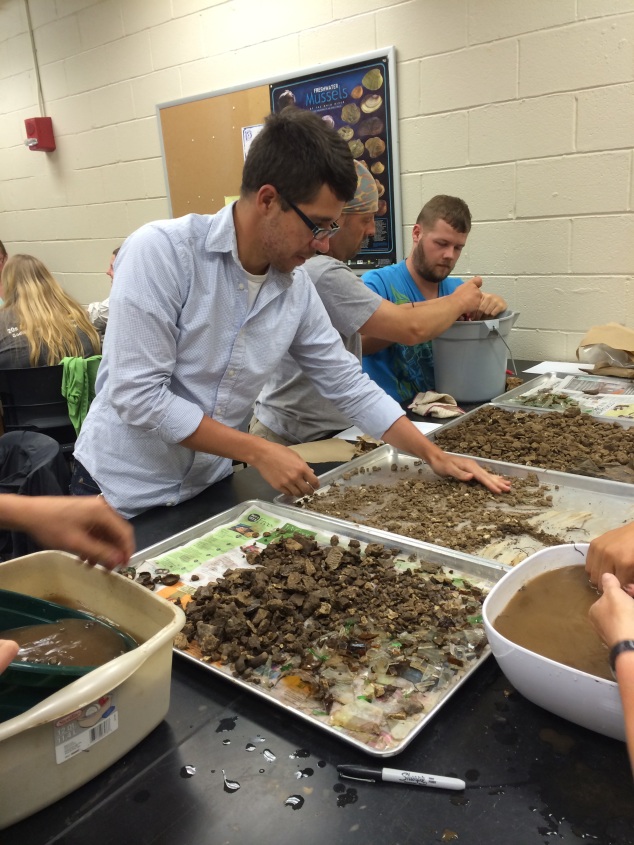
Artifact washing in the MTSU Archaeology Lab (Nathan Allison in the foreground, Josh Bicknell in the background; hands belong to various students who wish to remain anonymous).

Artifact washing in the MTSU Archaeology Lab (Nathan Allison in the foreground, Josh Bicknell in the background; hands belong to various students who wish to remain anonymous).


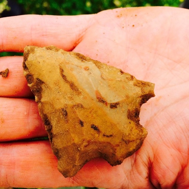
Finally, Wednesday morning arrived, sunny and mild. Everyone was ready to be on-site and move more dirt! We are all in the groove of the daily morning routine of uncovering the units and setting up the equipment in the mornings, schnitting, troweling, filling out paperwork, and screening for artifacts. Everyone knows what an artifact is — any object made, modified, or used by humans.

Obvious artifact: stemmed spear point made from chert.

Obvious artifact: stemmed spear point made from chert.


This week we introduced the students to the art form of feature identification. A feature is a non-moveable area that indicates human activity — such as a hearth, building wall trench, or storage pit.  Features are some of the most important things we identify in the field and why we excavate in a controlled scientific manner. Identifying features is a bit of an art form  and involves a lot of standing back and studying the soils exposed in the excavation units to determine changes in colors/textures/inclusions. Sometimes these changes are flick-you-on-the-forehead-obvious; other times it takes the trained eye of a seasoned archaeologist to tease them out.

Jessica O. trowels the floor of this unit to expose Feature 6.

Jessica O. trowels the floor of this unit to expose Feature 6. The unit directly to the west (the right in the photo) will be opened next to capture more of the feature. 

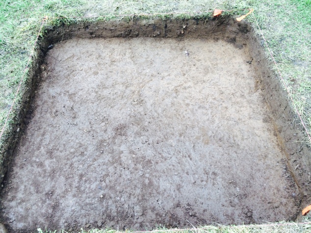
Can you spy the feature (Feature 4) in this color photo? (Scroll down to the next picture to see the unit in black & white.)

Feature 4, color photo (not an official photo for curation purposes).

Feature 4, color photo (not an official photo for curation purposes).


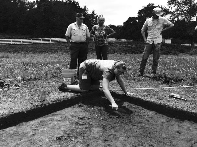
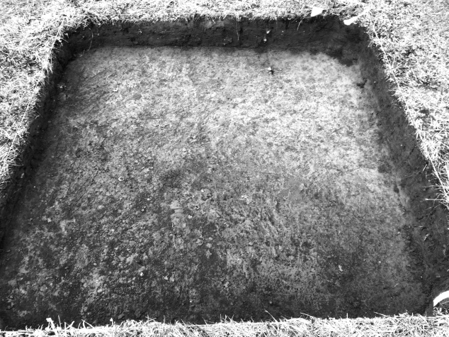
Same unit, only with a black and white filter applied (again – photo is for illustrative purposes, NOT an official curatorial photo). NOW do you see the feature? (Hint: it is dark soil on the lower 1/2 of the unit).


Feature 4, black and white filter applied.

Feature 4, black and white filter applied.


So far we have identified 5 cultural features (meaning ones created by humans) and one non-cultural feature (meaning likely remnants of where a tree or root once were). The five cultural features are in areas that we targeted specifically due to the remote sensing data Tim DeSmet generated early in the project. Over the next two weeks we will continue to expose these features by opening up adjacent units. We will then document them (by mapping the plan view and photographs) before excavating them. More on that in a later post.


Looking to see who visited us this week? Check out our Facebook page and Flickr account for photos!


The Road(s) Less Traveled

 — post by Susan London-Sherer, Historical Archaeology/Historic Preservation Graduate Intern

As MTSU’s first Public History graduate student to pursue an internship in historical archaeology, I must admit, I feel like a trailblazer.  As it turns out, I am not the only trailblazer to have spent some time toiling away in the hot sun at Magnolia Valley.  Last week, one of our excavation units in Area A revealed a long-hidden secret. The field school students who began the excavation quickly found themselves shoveling what appeared to be uniform-sized rock, and lots of it!  A very curious find indeed, in the middle of this lovely pasture.  As the excavation moved along, it became evident that the feature we were uncovering closely resembled a road.  With this information in mind, my next step was to do research on some of the earliest roadways in the College Grove and Allisona areas, and to try to discover who built these roadways, and for what purpose.  There is no better place to research Tennessee history than at the Tennessee State Library and Archives in Nashville.
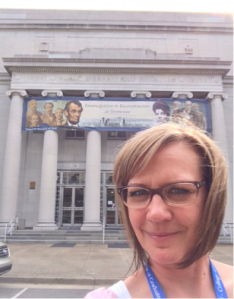
Susan the graduate intern at the State library and archives.

Susan the graduate intern at the State library and archives.

With the help of some great people, I have been able to uncover some fascinating details about the property over the past few weeks.  Steve Rogers at the Tennessee Historic Commission helped me to discover that this property was once part of a 1784 North Carolina land grant in the amount of 5000 acres to Hardy Murfree, Lieutenant Colonel of the First Regiment of the North Carolina Continental Line.  Land grants were regularly given to families of soldiers who fought in the Revolutionary War.  A standard amount that appears over and over in the records is 640 acres, exactly one square mile.  Other American patriots were also gifted with land grants, and some began selling off their land without every having laid eyes upon it.  Robert Nelson began selling some of his land in 1788.  John Topp bought some this land and eventually sold it to William Ogilvie and James Allison.  These were some of the earliest documented people to have owned land in the College Grove/Allisona area.  In 1793, David and William Wilson appear in the deed books, receiving land grants for 640 acres and for 2,000 acres.

With early settlers coming to the region, setting up homesteads and farms, roads would most certainly have become a necessity by the early 1800s.  Jay at the Tennessee State Library and Archives helped me fill in some of blanks by leading me to some excellent sources about early Tennessee roads.  Route 31A, also known as Henry Horton Highway, is one of the oldest traveled thoroughfares in Middle Tennessee.  It is believed to follow a route similar to an ancient Native American trail that connected with the Ohio River in Kentucky and then moved southward past the Tennessee River, and into the Huntsville, Alabama area.  According to William N. Lloyd’s article in the Marshall County Historical Quarterly (Winter 1973), “The first white men coming through Middle Tennessee identified the primitive path as the trail to the Fishing Ford.”  The Ford was just south of modern-day Chapel Hill near where the 31A bridge crosses the Duck River today.  Lloyd wrote, “northern and southern Indian tribes used the trail in commerce and war with each other, as well as to travel to the fantastic neutral hunting ground in Tennessee for major sources of meat.”

The Fishing Ford trail map courtesy of College Grove History,  TN State Library and Archives

The Fishing Ford trail map courtesy of College Grove History,
TN State Library and Archives

The exact route that the trail to Fishing Ford followed through Williamson County is not well documented, but the trail appears to have come through the present-day College Grove area and relatively close to our site.

Soon after Williamson County was formed in 1799, county officials began working on public roadways by cutting and clearing old Native American Trails.  This marked the first of three distinct stages of road building that developed the Fisher Ford trail into the modern thoroughfare that it is today.  The second stage was the turnpike era of the mid-1800s, and third was the state road-building era of the early 1900s.  Throughout the time period 1807-1809, the county court appointed local men to construct a road from James Allison’s property in present-day Allisona toward the Fishing Ford.  Among the men appointed were three of the Wilson brothers, Aaron, James, and Zaccheus, along with John Ogilvie and George Allison, some of the earliest settlers to the region.  Beginning in 1810, the court appointed various men to oversee the operation and maintenance of the road that had been built.

I am still researching whether or not James Allison ever owned the 372-acre property that our site occupies.  Currently, there is a gap in the deeds from our original land grant of 1784 until 1836 when James B. Russell sold the first 460 acres of land to the man we once thought was our original property owner, Mr. William McDowell.  Obviously, there is a lot more to the story that still needs to be uncovered.  Could the section of road in our excavation unit possibly be related to the 1807 court appointed road that began on James Allison’s property?  How many times did the property change hands in the 50 years that still remain a mystery to us?  Perhaps the discovery of a long-forgotten road, buried deep beneath layers of dirt and time in a farm pasture, has the ability to open up new avenues of discovery.  At some point in time, people blazed a trail across present-day Allisona, across the property that we are now searching for clues to the past.  Over the next few weeks, we will tirelessly continue to follow the trail.